Monday, November 17, 2014

Pamet Roads in the Late Autumn

In the heathland

Go to Pamet Roads in the late autumn.  Leave behind the anxiety of modern living.  Walk the sandy paths through the heath toward the sea.  


Shed near former cranberry bog

Pass the remains of an old cranberry bog, overgrown with twisted shrubs and leaning saplings.  Read about the family that harvested here every fall for generations.


Old bog house

Puzzle over the second floor entrance to the old bog house.


Grass covered dunes next to the sea

Choose a comfortable seat on the side of a grassy dune.  Eat your lunch slowly.  Savor the sweetness of your apple while gazing over the wide sea.  

Dune cliffs

The beach below is deserted on this November afternoon, yet you don't feel lonely.


View to the northeast

Pause frequently to take in the many soft-colored views.

View to the southeast

Abandoned road partially covered during dune washover

The low dunes at Ballston Beach have been overwhelmed many times through the decades by the pounding ocean surf.  Huge breakers have surged into the fresh water marsh at the head of the Pamet river.


Fresh water marsh at head of Pamet River

Residents have placed warning signs asking visitors to tread lightly on the narrow barrier that separates the sometimes angry ocean from the fragile marsh.    


Hooded merganser on pond behind barrier dunes

At the end of your stay be as relaxed as these merganser floating peacefully amid shimmering reflections on this small pond.  So please, I urge you, go the Pamet Roads in the late autumn.


Sunday, November 2, 2014

Disputed Boundaries and Cape Coyotes

Nauset Spit

looking north toward Nauset inlet

Last week I walked along Nauset Spit from Priscilla's Landing to get some exercise and search for birds.  The Atlantic beach is about a half mile to the east from the parking lot at the landing.  The shoreline can be followed north for about 2 miles to Nauset marsh inlet.  Most of the dune and grass area above the high tide mark is posted to prevent dune erosion and protect nesting sites of endangered birds.  

Boundary

Permits can be purchased from the Town of Orleans to drive vehicles on the beach toward the inlet.  In recent years the inlet has been gradually migrating north due to the natural movement of sand caused by wave action and ocean currents.  This had lead to a controversy about who has jurisdiction over the northern portion of the spit.  Eastham officials claim that the new section of the spit is now within their town.  Orleans selectmen maintain that the northern section should remain under their control at least for the management of off road vehicles.  Recently, the National Park Service claims that this section is actually the property of the National Seashore.  Currently, there are signs about half way up the spit to prevent Orleans off road vehicles from driving into the Town of Eastham. There continues to be a legal tussle over this stretch of sand.  

Coyotes

As I approached the line of dispute, the signs became visible.  I also noticed a coyote disappearing into the dune grass behind the boundary.  I was curious and in no way surprised.  Coyote sightings have become very common on the Cape.  Most full-time resident tell stories of coyotes strolling through backyards and there are frequent reports of attacks on pets.  In rural areas howling packs can sometimes be heard during late night hours.  I heard a pack singing their mournful serenade for the first time in our Harwich neighborhood about a week ago when I awoke at 3 in the morning.  The cries made my heart beat faster and sleep returned slowly after the yelps subsided.       

coyote disappearing into the dunes

sign at the disputed boundary

I continued to stroll up the beach and after walking for another half mile, I noticed what I first thought was a large dog ahead on the beach.  Binoculars, however, showed this to be another coyote.

another coyote in the distance

This guy was reluctant to flee into the dunes.  Food was involved.  He was trying to drag the remains of a seal to a safer area.  

trying to drag his lunch to a protected area

As I approached, he finally decided to slink off.

slinking coyote

After a few minutes, I passed the remains of the seal and continued walking north.  After I had gone another 50 or 75 yards, I turned to look back down the beach and saw that the wily coyote had returned to complete his meal.  He was closer than before and I snapped a pretty good picture.

return to finish the meal

He is certainly a healthy looking specimen, well-fed and well-groomed.  He didn't appear to be overly concerned about my presence but I'm sure he was glad to see me depart.  These coyotes must be ecstatic over the property line dispute as they cannot enjoy dodging off road vehicular traffic.  Further along the spit many coyote tracks were obvious crossing back and forth between the marsh and the ocean.

In conclusion, there are three government organizations feuding over the north end of the spit, but the real story is that the coyotes have squatting rights and currently have real jurisdiction.

End of the Walk

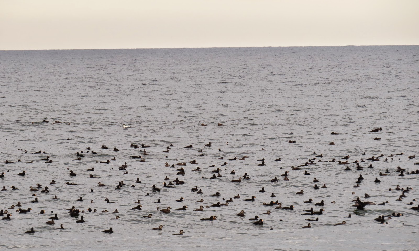
A huge flock of birds were floating in the sea near the inlet.  There were hundreds, mostly black scoter and white-winged scoter with some surf scoter and common eider mixed in.

floating birds (only a section of the flock is shown)  

I returned on the marsh side of the spit as the afternoon waned.

late afternoon sun and clouds over the marsh

Another fine Cape afternoon had passed.  A great deal had been accomplished.  I had burned some serious calories and as a bonus had sighted a huge flock of scoter.  Finally, I had acquired a firsthand understanding of the species that has practical jurisdiction over the north end of Nauset Spit, at least until an agreement can be hammered out between the towns and the National Park Service.
  

sunset from Priscilla's Landing

Friday, October 24, 2014

Wildlife in the Refuge


On this balmy autumn afternoon wildlife was in the  refuge.  Humans were few.  Birds were abundant.  Vireos and warblers were preparing for their southern migration.        

blue-headed vireo

yellow-rumped warbler

Others were making tracks in the sand.  

tracks

 It's tough to see the four-footed track makers, let alone get a photo.  Luck played a large part in snapping this coyote just before he was swallowed by the marsh grass.

making tracks

Another transcendent day on the marsh.

looking east towards South Beach 


Thursday, October 2, 2014

Protests and the Fall of the Wall

Hong Kong residents are taking to the streets this fall, protesting Beijing's oppressive influence on planned elections in their city.   Will these demonstrations succeed?  Could there be a repeat of the brutal crackdown of Tiananmen Square, the horror of June 4, 1989.  Or will there be a peaceful outcome?  

Normally this blog chronicles quiet walks of a retiree on Cape Cod beaches and marshes but retirees have time to travel, and travel sometimes leads to contemplation of world events.  In this entry, I give some photos and comments from a visit that Mary and I made to Germany this September.  Instead of beaches and marshes we walked the streets of Berlin and Leipzig, often overwhelmed by the sense of history in these cities.  

Berliners are celebrating the 25 year anniversary of the fall of the Berlin Wall this year.  The wall came down in November, 1989, just a few months after the failed demonstrations in Tiananmen Square.  We viewed many sections of the remainder of the wall, now preserved as a reminder of a divided Germany.  
A remaining section of the wall in central Berlin.  The writing on the wall reads "Save Our Planet."  
 Christian Fuehrer, a minister in Leipzig, lead parishioners in a weekly prayer for peace (Friedensgebet) in the Nikolaikirche during the autumn of 1989.  On Monday, September 4, the Friedensgebet spawned a demonstration of several hundred that spilled out into the streets.  The people of Leipzig were buoyed by the support of the church and protested for the right to elect a democratic government and the freedom to travel to other countries.        

Bicycles parked in front of the Nikolaikirche where the Monday Demonstrations of 1989 got their start.  
In subsequent weeks the news of what happened in Leipzig spread to other cities and protests became widespread across East Germany.  In Leipzig, the numbers participating in the Monday Demonstrations increased to 70,000 on 9 October, 120,000 on 16 October and more than doubled to 320,000 on 23 October. Military units were called in but were never ordered into action because officials feared unimaginable violence.  More than a half million gathered in Berlin's Alexanderplatz on 4 November.  The crowds were simply too large to control.  Thus, these Monday Demonstrations contributed to the fall of the Berlin Wall on 9 November.

Of course, the situation in Germany in 1989 was much different than circumstances in contemporary China. However, the Peaceful Revolution of 1989 which led to the fall of the Berlin Wall is living proof that mass demonstrations can lead to meaningful change.  Let's hope that a positive peaceful resolution can be achieved as a result of the current mass protests in Hong Kong and that a repeat of the horror of Tiananmen Square is avoided at all costs.        


Thursday, September 11, 2014

Wing Island Walk


Summer fades into fall.  Tourists hurry off Cape to catch the beginning of school.  We lucky full-timers remain anchored here, now free to follow whatever trail we wish, dawdle in the high marsh grass or lounge on warm sand beaches.  We return with quiet glee to Wing Island sanctuary.  The teeming crowds of kids who terrorized crawling creatures in "mud flat mania" are now safely sequestered in far-away classrooms.

We absorb the peace of Payne's Creek, swollen with high tide just about to ebb.

We ponder the myriad of emerald greens swirled into jaunty tufts by wind and water.   

Crossing the height of the island on shady forest paths, we catch a first glimpse of the distant bay under a low bank of cumulus.  
                                    

The path leads to the sea through a wide expanse of low grass that stretches the legs and calms the mind.

The open views from the beach lull us into dreamy meditation.

The interplay of black-bellied plover and dowitcher thrill the birders.

A juvenile ruddy turnstone surveys the scene.  

We can't neglect the scurry of semi-palmated plover at our feet.

One could do worse than spend an entire afternoon in reverie at Wing Island.  

Ah well, return home we must, guided softly through a cocoon of green.  

Enjoy those schooldays kids.  I'm home for a hot cuppa tea.  


Sunday, August 17, 2014

Morris Island Meditation


It was one of those perfectly glorious Cape days.  If only time could stop.  You want it to, desperately, to capture these magical luminous moments.  A southeast breeze ruffled the sparkling silver surface of the bay out of the southeast, the gentle salt wind cool against sun-warmed skin.  Scoured white fluffed-up clouds low over the distant horizon signaled continuing fair weather.  The marsh grasses have grown tall and dense from meager spring spouts, now a bounty of lush greens this August.


The tide was out and ebbing lower, allowing a slow stroll on the expansive mud flats with North Monomoy almost within reach across the channel.  And oh, an abundance of birds, hundreds of semi-palmated sandpipers were busily farming the flats, in a frenzied rush to feed their fill before the turning of the tide.  These flocks are only fleeting visitors, preparing for their long journey to South American shores.  Who knows how many will survive to enjoy the southern summer?  You wish them well and Godspeed on such a perilous trek for fragile little wings.  
  
If only all your friends and loved ones could be here to share this precious day.  Thinking of those far away and especially those who are gone forever, brings on a weighty feeling of melancholy, surrounded by all this beauty yet wistful, wishing that time could have stopped not today, but years ago when similar glorious days were shared by all.  Godspeed to all present and past friends and loved ones.          

Thursday, July 3, 2014

A Hike Back through Time

This June, my good old friend, Steve, and I walked down into the Grand Canyon and out again.  We had been planning this hike for quite some time.  Steve spent many hours on the phone a year ago getting reservations at Phantom Ranch, located at the bottom next to the Colorado River.  Space fills quickly the first day of each month for reservations that must be made one year in advance.

This is the view from the south rim at the head of the South Kaibab Trail, our starting point.  Yaki Point is in the right foreground.

The age of formation of the various rock layers visible in the canyons spans well over a billion years.  It is difficult to keep this in mind when descending into the canyon.  The topmost limestone layer was deposited 270 million years ago while the igneous and metamorphic rock of the deep inner gorge dates to almost 2 billion years.  Thus, when hikers dip into the canyon they are actually traveling back in geologic time.  This concept was made famous by Colin Fletcher in his 1967 book, The Man Who Walked Through Time.  Colin is the first to have continuously walked the length of the canyon from one end of the National Park to the other, a distance of over 1/3 of the canyon.  The total length of the Grand Canyon is 270 miles.    

Our trek would be slightly more modest, a vertical descent of 4780 ft along a 7 mile route of countless switchbacks to the river followed by climbing back out on the Bright Angel Trail a distance of 9.5 miles.  At the start there were lots of other hikers on these switchbacks with us.

We looked and felt energetic and fresh at the top despite having jet lag and toting AARP membership cards.  In the end we learned that this is not a trivial hike.    

On the way down we paused many times to admire the fantastic views and take pictures.  

This shot shows some of the limestone, sandstone and shale layers through which we descended.
  
When we reached this viewpoint, we started to recognize that the temperature was rising, much higher than the 70 deg at the beginning of the day.  The red rock heat was making itself felt.  We also noticed that there were now very few other hikers.  Almost all others were making this into a day hike and had turned to regain the rim.  A ranger stopped us on the trail.  She said that our packs looked light and asked if we had enough water.  She eventually let us pass although she was clearly not totally convinced that we were adequately prepared.  Of course, there was no question in our minds.  We pushed on.  

More switchbacks led us deeper into the silent heat, unshielded from the glaring sun.  The radiant heat from the hot rocks added to the feeling that we were baking in an oven.  

There is an emergency phone at the Tipoff, just before dropping into the inner gorge.  A thermometer read 100 F in the shade.  We were afraid to imagine the temperature in the sun.  

Finally, we got a view of the Colorado.  It's way down there and the trail is STEEP!!  If you look closely, you can see one of the two walking bridges. 

 We made it to the river.  This shot looks back toward the tunnel which leads to the bridge.  We didn't want to leave the tunnel.  There was shade and a breeze (although composed of  >100 F air).  It was nearly 3 pm.  We had started at 7:30 am.  The national park recommends a start no later than 6 am.  We now understand why.  Hot and tired does not nearly describe our discomfort.  I was flushed, slightly nauseous, and light-headed even after drinking liters of water and gatorade.  The lady ranger had been right to be skeptical.  What had started as a leisurely walk was ending as a struggle against heat exhaustion.  And tomorrow we would have to walk all the way back up!!!  I was having my doubts.  When signing in at the Phantom Ranch, I must have looked better than I felt, otherwise I'm sure the attendant would have called for first aid.   

The ranch is a rustic throwback to decades ago.  This is the dining room/mess hall where family style meals are served.  The food is excellent and all you can eat, although my appetite was somewhat subdued because of my bout with the heat.  We ate at a table with 8 Amish ladies who had walked down in long dresses.  They were chipper and all smiles, doing nothing for my ego.  

The accommodations are simple but adequate.  There are a number of small cabins for families (or Amish ladies).  We stayed in a dorm with 8 other hikers.  The bunk beds were comfortable.  The shower felt so, so good and even better, the dorm was air-conditioned.   This was lucky for us because when we arrived the temperature was 107 F in the shade.  Sleeping would have been impossible without the cooling unit.  

Steve had no trouble convincing me that we should sign up for the early breakfast.  At 4:30 am came a knock on the dorm door.  We were on the trail by 5:30 am.  This is a view downstream from the walking bridge just after leaving Phantom Ranch.  

We dreaded the rising of the sun over the canyon rim.  We were unsure of the temperature in the morning.  It was warm but in no way comparable to the heat of the previous afternoon.  
  
Because of our early start, we were able to climb for several hours in the shade.  Climbing out was definitely easier than climbing down, all due to the heat.  As we climbed the temperature did not increase.  It is simply cooler at higher elevations even though the temperature increases during the day.  

After conquering many, many switchbacks we again began to meet the day hikers who only descend partway from the El Tovar lodge into the canyon.  

When we arrived at the top, I was quite emotional.  We had traveled back through geologic time and back through decades to a ranch that marvelously has not changed much since early in the last century.  We had also regained a glimpse into our youth, to a time when this would have been more like a cake walk.  However, this was truly an accomplishment for me and a great experience which I was fortunate enough to share with my very good friend, Steve.  We're already planning our next adventure hike.  

P.S.  Another reason I felt so emotional at the end of this hike was my memory of a trip Mary and I had made to the canyon more than two decades ago with our two boys.  Tim, Lucas and I had walked down to the river from the south rim and out to the north rim, camping two nights in the canyon.  Mary drove around to meet us at the north rim.  That was a very special time when I bonded with my sons.  I only wish the trip could be repeated so that we could be together again.  I'm dedicating the hike this year to my two precious sons, Lucas and Tim.