Thursday, July 3, 2014

A Hike Back through Time

This June, my good old friend, Steve, and I walked down into the Grand Canyon and out again.  We had been planning this hike for quite some time.  Steve spent many hours on the phone a year ago getting reservations at Phantom Ranch, located at the bottom next to the Colorado River.  Space fills quickly the first day of each month for reservations that must be made one year in advance.

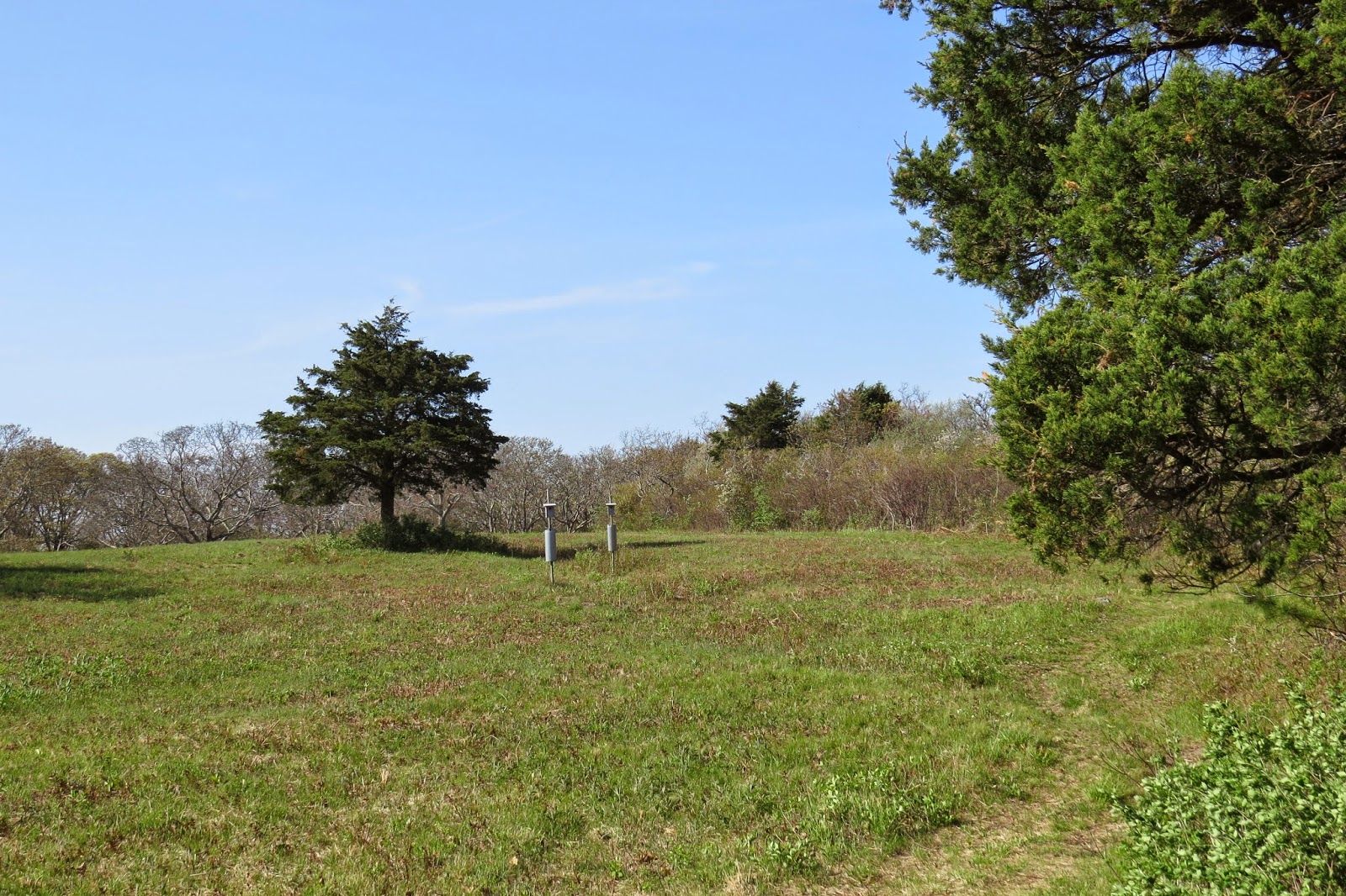
This is the view from the south rim at the head of the South Kaibab Trail, our starting point.  Yaki Point is in the right foreground.

The age of formation of the various rock layers visible in the canyons spans well over a billion years.  It is difficult to keep this in mind when descending into the canyon.  The topmost limestone layer was deposited 270 million years ago while the igneous and metamorphic rock of the deep inner gorge dates to almost 2 billion years.  Thus, when hikers dip into the canyon they are actually traveling back in geologic time.  This concept was made famous by Colin Fletcher in his 1967 book, The Man Who Walked Through Time.  Colin is the first to have continuously walked the length of the canyon from one end of the National Park to the other, a distance of over 1/3 of the canyon.  The total length of the Grand Canyon is 270 miles.    

Our trek would be slightly more modest, a vertical descent of 4780 ft along a 7 mile route of countless switchbacks to the river followed by climbing back out on the Bright Angel Trail a distance of 9.5 miles.  At the start there were lots of other hikers on these switchbacks with us.

We looked and felt energetic and fresh at the top despite having jet lag and toting AARP membership cards.  In the end we learned that this is not a trivial hike.    

On the way down we paused many times to admire the fantastic views and take pictures.  

This shot shows some of the limestone, sandstone and shale layers through which we descended.
  
When we reached this viewpoint, we started to recognize that the temperature was rising, much higher than the 70 deg at the beginning of the day.  The red rock heat was making itself felt.  We also noticed that there were now very few other hikers.  Almost all others were making this into a day hike and had turned to regain the rim.  A ranger stopped us on the trail.  She said that our packs looked light and asked if we had enough water.  She eventually let us pass although she was clearly not totally convinced that we were adequately prepared.  Of course, there was no question in our minds.  We pushed on.  

More switchbacks led us deeper into the silent heat, unshielded from the glaring sun.  The radiant heat from the hot rocks added to the feeling that we were baking in an oven.  

There is an emergency phone at the Tipoff, just before dropping into the inner gorge.  A thermometer read 100 F in the shade.  We were afraid to imagine the temperature in the sun.  

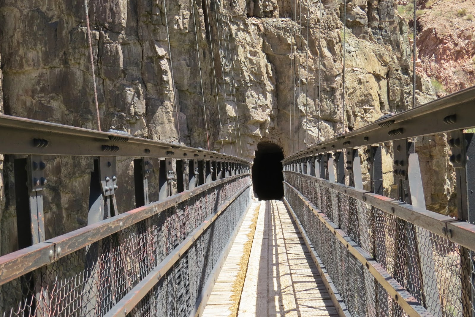
Finally, we got a view of the Colorado.  It's way down there and the trail is STEEP!!  If you look closely, you can see one of the two walking bridges. 

 We made it to the river.  This shot looks back toward the tunnel which leads to the bridge.  We didn't want to leave the tunnel.  There was shade and a breeze (although composed of  >100 F air).  It was nearly 3 pm.  We had started at 7:30 am.  The national park recommends a start no later than 6 am.  We now understand why.  Hot and tired does not nearly describe our discomfort.  I was flushed, slightly nauseous, and light-headed even after drinking liters of water and gatorade.  The lady ranger had been right to be skeptical.  What had started as a leisurely walk was ending as a struggle against heat exhaustion.  And tomorrow we would have to walk all the way back up!!!  I was having my doubts.  When signing in at the Phantom Ranch, I must have looked better than I felt, otherwise I'm sure the attendant would have called for first aid.   

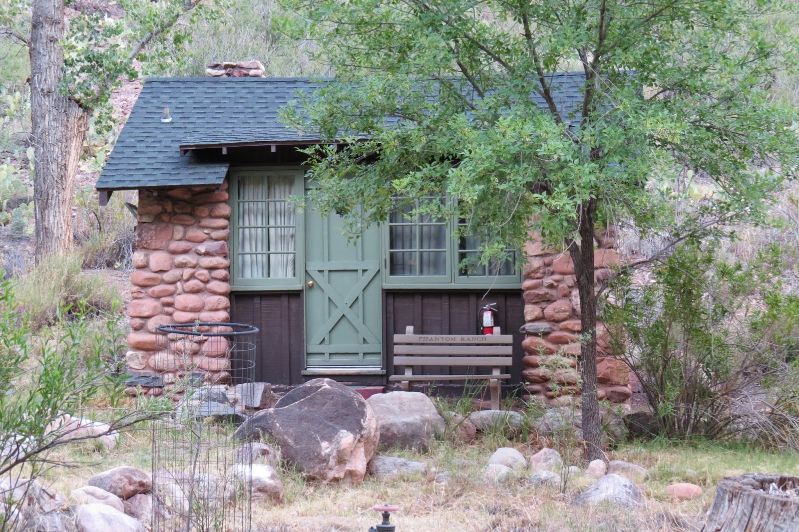
The ranch is a rustic throwback to decades ago.  This is the dining room/mess hall where family style meals are served.  The food is excellent and all you can eat, although my appetite was somewhat subdued because of my bout with the heat.  We ate at a table with 8 Amish ladies who had walked down in long dresses.  They were chipper and all smiles, doing nothing for my ego.  

The accommodations are simple but adequate.  There are a number of small cabins for families (or Amish ladies).  We stayed in a dorm with 8 other hikers.  The bunk beds were comfortable.  The shower felt so, so good and even better, the dorm was air-conditioned.   This was lucky for us because when we arrived the temperature was 107 F in the shade.  Sleeping would have been impossible without the cooling unit.  

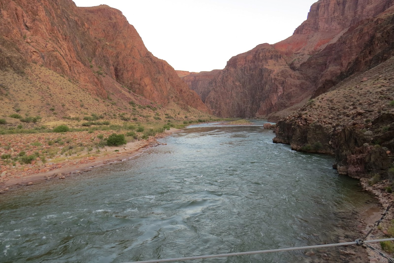
Steve had no trouble convincing me that we should sign up for the early breakfast.  At 4:30 am came a knock on the dorm door.  We were on the trail by 5:30 am.  This is a view downstream from the walking bridge just after leaving Phantom Ranch.  

We dreaded the rising of the sun over the canyon rim.  We were unsure of the temperature in the morning.  It was warm but in no way comparable to the heat of the previous afternoon.  
  
Because of our early start, we were able to climb for several hours in the shade.  Climbing out was definitely easier than climbing down, all due to the heat.  As we climbed the temperature did not increase.  It is simply cooler at higher elevations even though the temperature increases during the day.  

After conquering many, many switchbacks we again began to meet the day hikers who only descend partway from the El Tovar lodge into the canyon.  

When we arrived at the top, I was quite emotional.  We had traveled back through geologic time and back through decades to a ranch that marvelously has not changed much since early in the last century.  We had also regained a glimpse into our youth, to a time when this would have been more like a cake walk.  However, this was truly an accomplishment for me and a great experience which I was fortunate enough to share with my very good friend, Steve.  We're already planning our next adventure hike.  

P.S.  Another reason I felt so emotional at the end of this hike was my memory of a trip Mary and I had made to the canyon more than two decades ago with our two boys.  Tim, Lucas and I had walked down to the river from the south rim and out to the north rim, camping two nights in the canyon.  Mary drove around to meet us at the north rim.  That was a very special time when I bonded with my sons.  I only wish the trip could be repeated so that we could be together again.  I'm dedicating the hike this year to my two precious sons, Lucas and Tim.   

Tuesday, June 3, 2014

Province Lands Walk

One day in late May I spent a few hours hiking the dunes of the Province Lands at the tip of Cape Cod.  I started from a parking area adjacent to Route 6 near Pilgrim Lake.  After passing through a pitch pine forest for a hundred yards, the trail abruptly opened to a wide blue sky over a broad expanse of rolling sand hills thinly covered by bright green grasses bending in the wind.  


The path wound through the dunes.  Soft sand made for slow going.  But who cares about speed when surrounded by this uniquely beautiful landscape.


These Province Lands are within the Cape Cod National Seashore, administered by the National Park Service.  The bill creating the CCNS was  signed into law by President John F. Kennedy on August 7, 1961.

Nineteen shacks are nestled in the dunes within the Peaked Hill Bars Historic District, a part of the Province Lands.  These were built starting about 1920.  A number of writers and artists were drawn to this remote location to tap their creativity in simple (there is no electricity or running water) solitude. Eugene Oneill wrote two plays while staying in one of the shacks.  Others who stayed here include Jack Kerouac, E.E. Cummings, Jackson Pollack and Norman Mailer.

I came across this group of shacks near the beach after walking almost a mile through the dunes.
  

There was a strong east wind buffeting this shack, not yet opened for the season.    


  I had a peaceful lunch sitting on a bluff overlooking the white-capped Atlantic.


A flock of black scoter were riding on the swells.  (Sorry, I had to include this picture due to my current addiction to birding.)  


On the return, I enjoyed the vivid color of salt-spray roses.  


I was so moved by the surroundings that I was almost inspired to write a play or maybe a poem in these magical Province Lands.  It is comforting to know that special places like this are preserved. Who knows?  I might actually write that poem during the next visit.     


Sunday, May 18, 2014

Common Contradictions


There are numerous beautiful preserves on Cape Cod, almost too many to count.  For example, Crowe’s Pasture is a protected area on Quivet Neck in the Town of Dennis.  The pasture consists of open rolling fields dotted with copses of trees and bushes.  Four wheel drive vehicles pass through  down to the beach where Quivet Creek enters Cape Cod Bay.  

At low tide trucks can be seen out on the flats, their owners harvesting delicious oysters. 

When I visit the pasture it is without wheels or engines but on two feet.  A trail starts just past the old cemetery and winds along the marsh.  Shortly down from the start, the path crosses an arm of the marsh on a low berm.  

Seawater rushes to and fro through a tidal cut mid-way along the berm.  The gap is spanned by two long wide boards which become awash during high water.  

The view over the low grasses to Quivet Creek is expansive.  Ospreys nest on a pole provided by a local nature group on the far side of the creek.  At the end of the berm the way leads through a mixed forest with an understory of low brambles.  

Further on the path opens to Crowe’s broad pasture where bird houses perch on low squirrel-protected poles.  

On a day in late April I followed a beautiful little Phoebe from bush to bush with my field glasses. Song sparrows voice their soft notes and robins hop then stop in their constant ground search.  Tree swallows dart overhead and hawks soar high above.       

In such a peaceful place, it is sometimes possible for me to lose touch with a growing feeling of despair about the future of the earth.  This precious earth we have known since childhood.  The tragedy of the commons is playing out like a sad drama before our eyes in so many ways.  

On the Cape, cod is an ever present icon but stocks have all but disappeared on Georges Banks and in the Gulf of Maine.  Mechanized fleets devastated fishing grounds starting in the 50’s and 60’s continuing through 1992 when the cod harvest collapsed.

File:Surexploitation morue surpĂȘcheEn.jpg

Our species increasingly dominates, not only on the regional scale of the cape.  The effect of our controlling presence is so profound that scientists now recognize that the global ecosystem is in the midst of the sixth great extinction, the greatest decline in diversity since the dinosaurs disappeared 65 million years ago.  Estimates are that 30 to 50% of the species on earth may disappear by mid-century.  We not only crush other species directly but also devour their habitat. 

It is admittedly hard to believe that humans are causing species extinction at a rate that is over 1000 times the background rate (rate before the appearance of humans) and quite difficult to imagine that our industries, transportation systems and deforestation practices are altering the chemistry of entire oceans and changing the climate of the whole world.

As a youth, I viewed nature as independent of towns and cities.  The rural environment was to me an immutable constant that existed as a comfortable refuge, independent of urban development, military conflicts and other activities of man.  But over the years my innocence has been punctured with the knowledge that we are changing the ecosystem on a global scale.  It is indeed frightening and overwhelming.  So much so that I can understand why so many simply deny or ignore the vast extent of our impact.

So what do we do?  We proceed with our private lives in a contradiction of activity.  We conserve on a local scale.  We beautify our homes and gardens, set aside local conservation trusts, preserve the beaches at the Cape Cod National Seashore, while we ignore the degradation of the global ecosystem.  We live in a world of contradictions, enhancing our private surroundings while despoiling the common.  

Oh well, it’s time for my walk on the beach.    

 I plan to soak up the beauty of the sea and ponder the future of our little earth.   

Wednesday, April 30, 2014

Birdshots - April Cape Cod

Saw this hermit thrush in Nickerson State Park the other day.  Took a long time and a lot of patience to catch him in this pose. 
 
This blue bird is sitting on our backyard feeder. 
 
 
Is this a normal color for a turkey?  He likes our deck. 
 
 
I had trouble identifying this one but have decided on a female brown-headed cow bird. 

Tuesday, April 8, 2014

Downed Eider

I have seen them on the grey frigid water throughout this harsh winter.  They first came in nervous flocks on cool fall winds to Cape Cod Bay, skimming low, first east then west from beach to beach, searching a haven from colder winds and shorter days. 

In January I saw them hunkering down in Nauset Marsh before one of the worst blizzards, in amazingly great numbers, clouds of common eider fleeing from the open sea to the meager protection of the low sand spits and grasses.       

I walked the Morris Island Beach in Chatham at least twice a month this past season.  On each visit they lingered in the distance floating together toward North Monomoy away from contact with humans.  They were so numerous that I became dismissive of their presence, searching always for rarer visitors to the wildlife refuge.

But on this day, I came upon an eider pair up close and personal.  They both lay beached above the patchy wrack line, never to take to the air or sea again.  This lonely couple were downed forever, one a handsome male with black cap and striking white down, the other a pretty female with soft mottled brown feathers.  Up close they seemed larger than I had imagined.  Both were recently beached, plump with preened coats, with a healthy look, in disturbing contrast to their contorted attitude of limp death. 

The female had been tagged previously in Rhode Island by an unknown government employee.  Records show that she had been born in 2010 or before.  I tried to imagine her traveling with her companions north and south along the coast over these years, maybe finding some birdlike form of happiness coasting over the bays and floating on the inlets.  Now she has died with a companion of her own species and has been recorded in the archives of man, nameless but numbered. 


Monday, March 24, 2014

A Walk Through a Former Time

On a cool, breezy day in mid March I walked about a mile and a half south on the jeep road from the end of the Nauset Beach parking lot in East Orleans.  My goal was Pochet Island.  Access is across a narrow wooden bridge over a creek in the marsh which separates the island from the beach. 
Four wheel drive vehicles can navigate the jeep trail and the bridge to travel on a few cart paths on the island.  Hikers are welcome to walk back in time through the watery tide-sensitive approach to Pochet.   
The handful of summer homes and cottages were all boarded against the winter winds.  There does not appear to be any electrical service.  The largest home, labeled "new house" is perched on a hill fronted by open fields.  I arrived about noon and sat on the porch to escape the northwest breeze and absorb some grudging warmth from a hazy sun mostly obscured by high clouds. 
The views to the ocean are expansive.  The rustic appearance of the homestead, perfectly placed in a rolling rural landscape, evoke sensations of a simpler time, lost ages ago. 
 I had to remind myself while eating my modest brown bag lunch that this was not a pleasant dream but an actual idyllic enclave just beyond the jagged edge of our electronic, mechanized age. 
Public access to groomed paths is part of a Conservation Restriction agreement made between residents and the National Park Service in 1975.     
 A small forest pond lies in the center of a maze of thickets. 
 The views to the south and west over Pleasant Bay and on to Chatham are spectacular. 
After several hours of pensive strolling, I left behind this little piece of paradise with regret but comforted in the knowledge that places as wonderful as Pochet still exist. 


Thursday, February 27, 2014

Refuge in the Fog

Fog surrounded the Morris Island National Wildlife Refuge this morning.  I was alone on the beach walking the wrack line.  Others preferred to stay home in front of warming fires. 
 
Slowly the visibility decreased.  Who doesn't sometimes opt to disappear into an obscuring mist faced with the alternative of confronting the raw reality of prejudice, injustice, and poverty outside of our protected lives.   
 
A few scattered Horned Grebes navigated within this refuge without concern for the troubles of the external world. 

In the darkening afternoon even more dense cloud blankets rolled in from the sea. 
 
One lone fisherman eventually was lost from view. 
 

On returning I chose the inland route, intimidated by the somber grey fog. 
 
So cowed by the leaden cold damp mood of the shore which no longer seemed like a refuge, I left the beach behind, glad to retreat even further from the reality of the world to a warming fire at home.   No medals for heroism would be awarded today.   There is always tomorrow.